 The extended forecast showed sunny little icons for the next 7 days, which for Oregon in February is a blessing, so I’m told. The rain had stopped and we sat atop Dog Mountain in the Columbia River Gorge, eating chocolate pretzels and watching the little barges beneath us push their cargo up and down the river. We had driven east out of Portland the night before, finding a fairly level spot to park the van for the night and fell asleep with the sound of Multnomah Falls swishing through the roof vent. The climb that morning reminded us that we’d gotten soft since finishing the AT three months prior, although unlike most of the AT, this slog ended with a view. To the south, the tippy top of Mt Hood rose from the foothills, and to the north and northwest stood Adams and St Helens, blanketed by snow and standing in deep contrast to the blue sky. We’d tossed around the idea of climbing St Helens for weeks, and here was a perfect window; mild temps, no precip, calm winds. We decided to summit the next day.
Driving back into the city we hashed out the plan. Shove gear into our backpacks, throw some food together, rent crampons and ice axes from Next Adventure. Check, check, check. North on I-5, South on 503, Rt 90 East and follow the signs to Marble Mountain Sno-Park. Was it really that close? As a child raised back East, climbing volcanoes was akin to swimming to the moon. Yet here we were, preparing for an alpine start and not another car in the parking lot.
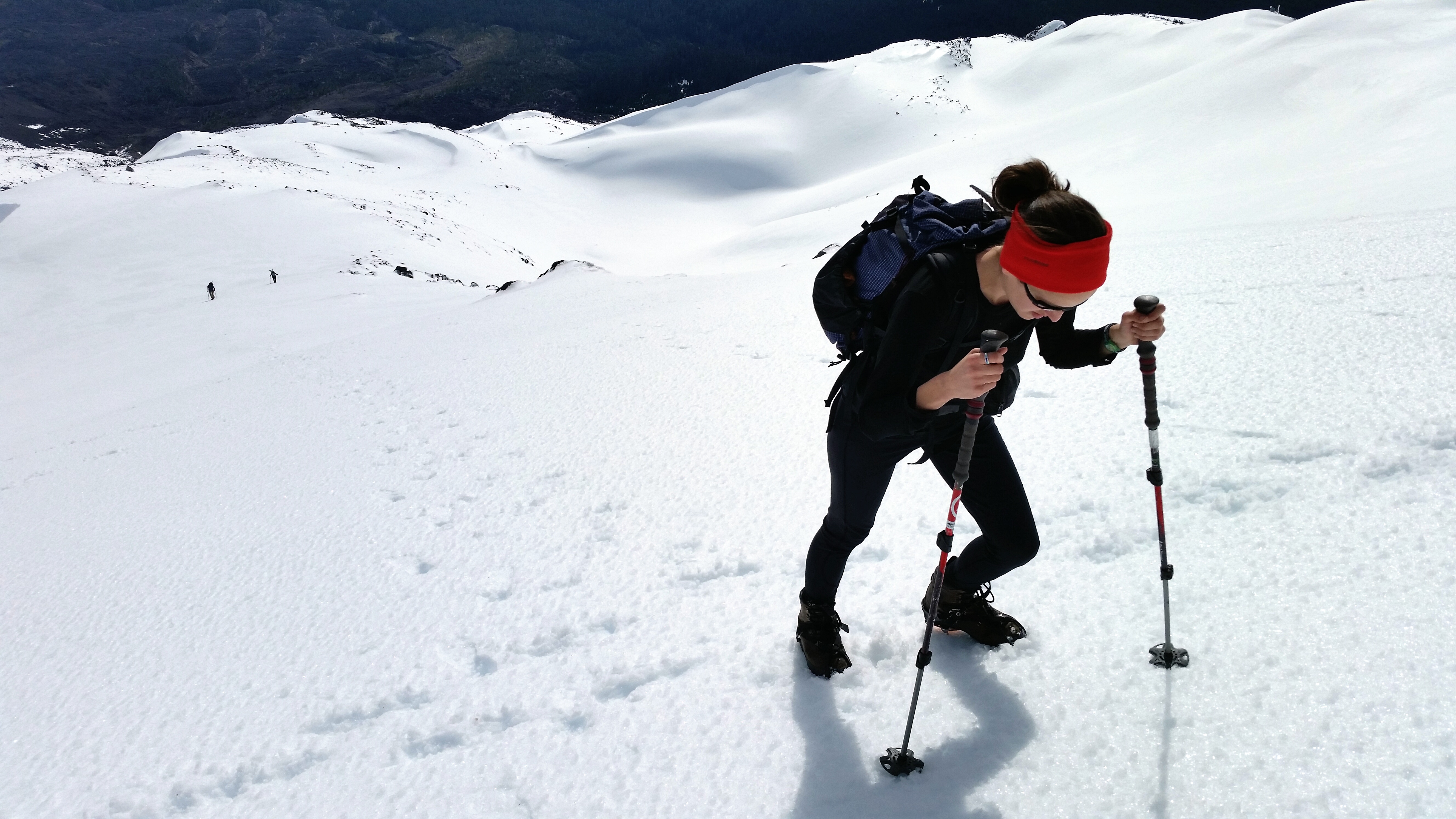
We woke at 6:30 and blearily brewed a thermos of coffee for the approach, had a bite, and set out. There was one other person there, probably an hour ahead of us. We made our way down the well-trodden path as the coffee worked it’s magic on our brains and our muscles ached from the climb the day before. After several miles we turned out of timberline, across Swift Creek and onto the rivers of rocky lava that lead to the summit, known as the Worm Flows. We followed a rocky spine for several hours before reaching snowline, where we threw our Kathoola Microspikes on over our trail runners. After the first pitch the climb became steep and opened into snowy chutes, so out came the boots and proper crampons. Clink, clank, chick, cssshhhh goes the sound of rented mountaineering gear against the silent slopes.
We’re climbing with our toes straight up what feels like a near vertical pitch, which in reality was probably more like 45-50%. Visions of cracks forming in the snow, the sound of release, slabs of white turning into a raging river of winter fury burying everything in its path. Swim it out, I remember the advice I’d heard somewhere about what to do if caught in an avalanche. Ditch the pack, clear a pocket around the mouth for breathing. Try to stick an arm up to the surface before the snow settles around you like concrete. Seems like a lot to recall as I try to keep a line to the far right, near some rocks that may offer stability. Looking back Virginia is getting comfortable in her crampons, chick-chick-chicking up the crusty slope. One hundred yards behind her are two climbers, following our path. I bury the anxiety and focus on making forward progress.


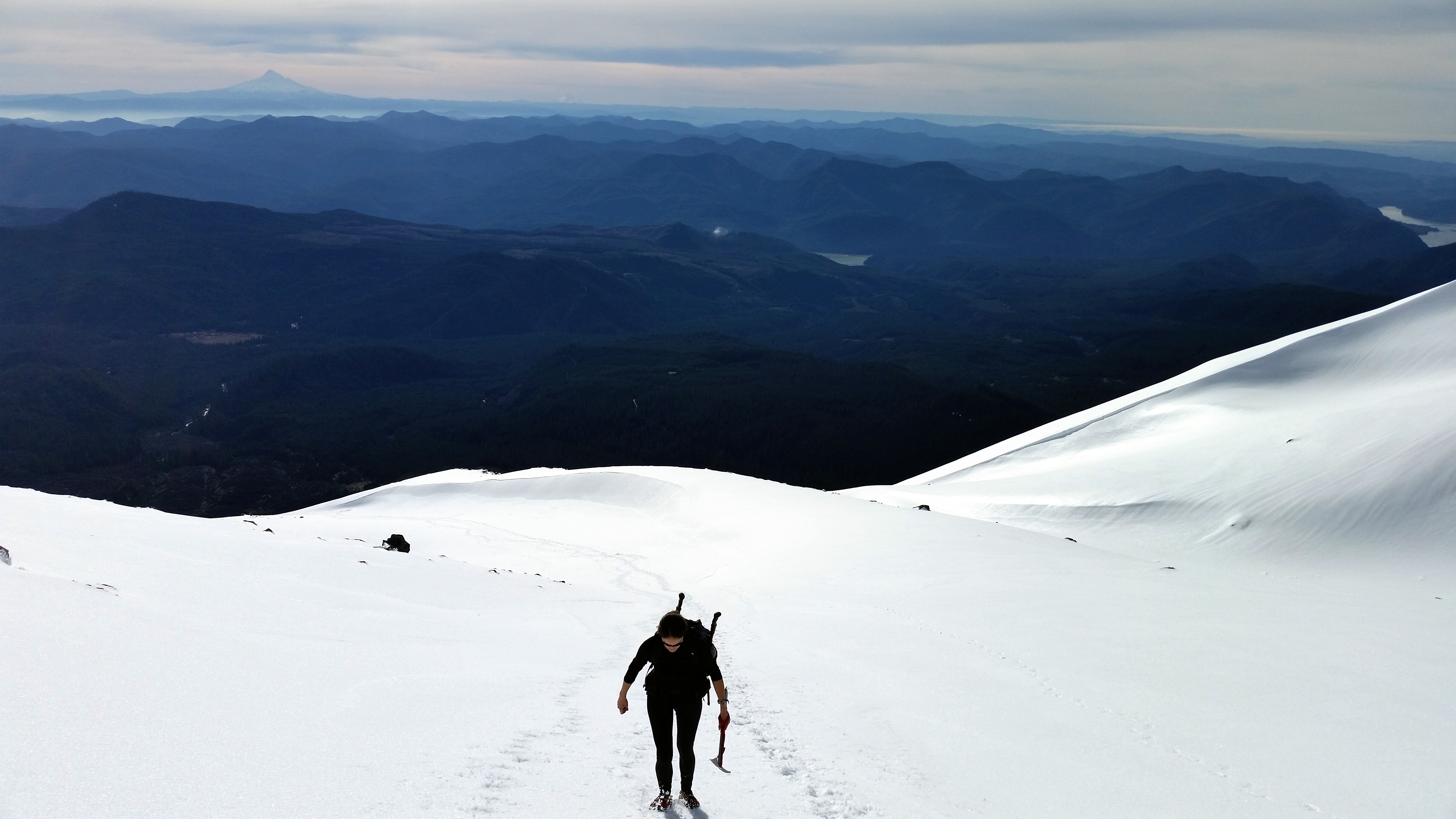
Hours of climbing and several false summits later, we turn left up the final slope and pass the first climber of the day. He’s just come from the rim and points upslope, saying it’ll probably take us another half an hour to get to the edge, and to be careful because it comes on rather suddenly. Looking up it appeared to be less than 200 yards away, but sure enough we reached the edge of the crater 30 minutes later. Baby steps, baby steps towards the sudden drop. We look up from our boots, and before us lay the remnants of the largest landslide in recorded history, an entire mountainside blown out after the 1980 eruption. That iconic series of photos flash through my head; the northern section gives out, steam and ash billowing up and out 16 miles high,
earth process in motion. And here we stand on the rim, peering down into the steaming crater. We’ve learn from the climbers behind us that we’ve taken a different path to the rim, several hundred feet higher and west of the saddle where most winter climbers summit. Dogs Head and Goat Rocks form the northern edges of the crater before dropping off into the breach zone, and are quite visible from our position. The 1980 dome bulges and steams beneath us. Spirit Lake sits glistening to the north, punctuated by Mt Rainier just above. Adams rises twelve thousand feet into the air to the east, with Hood and Jefferson visible to the south. Unlike the long ranges of the Rockies or the Sierras, these mountains stand solitary and stoic, flanked by modest foothills, owing their bilateral symmetry to their volcanic origins.

The two women behind us finally reach the top and after several oohs and ahhs we all plant ourselves on the still sloping face, looking south, and eat. Someone drops their energy gel packet and it slides down the smooth surface gaining speed before catching the edge of a depression and stopping. The sweet and salty snacks restore our force de vie and we prepare for descent, trading cameras for photos before heading down. The crampons allow us to descend quickly, with a sensation similar to walking down a sand dune. But we gladly removed them when we realized glissading was the preferred method of descent. With our butts on the slope and our feet in front, we gleefully slid down the mountain, using our boots and ice axe as a brake. With shit-eating grins we descended in thirty seconds what took thirty minutes to climb. If winter had been in full force, we could have glissaded all the way down to timberline and hiked two miles back to the parking lot. As it was, we would slide to a shelf, scout a new line, slide, stop, repeat. By the time we reached the rocky spine of the Worm Flows, our asses were numb and our faces locked in a perma-grin. We wanted to go back to the top and do it again. Instead we scrambled down the route as the sun sank lower to the west and south, moving slowly until we reached treeline and were able to walk at a normal pace. Terra firma under our feet, we glance back at the glaciated mountainside. We were two of the five people to climb it that day and the last to leave. Cars begin to accumulate in the parking lot, full of folks that would ascend and descend the volcano the next morning.

We decide to skip heading back into Portland right away, and instead drive north through the night to Tacoma, and turn east making our way to the little town of Roslyn, also known as Cicely, Alaska on the 90’s show Northern Exposure. We sleep in a truck turnout on Snoqualmie Pass, and drop into Roslyn early the next morning for breakfast and photos, and possibly the best Valentines Day ever on the set of my favorite show of all time. I got to sit in for Chris in the Morning, hang out in Dr. Fleishman’s office, and have a beer before noon at The Brick, all the while whistling that catchy intro, over and over.

Great story and it looks like you got some beautiful photos out of your experience.
Hey Guys!
Your narrative and photos are amazing. The adventures continue! It reminds me so much of my experience in New Zealand – crampons and ice axes, and digging an ice cave to spend the next 18 freezing hours in due to an unforecasted blizzard. But the best part (just like you said).was the reward of bum-sliding our way down the mountain the next day. What a well-earned thrill! You guys are incredible and I miss you!
Lauren
Spectacular views! Thanks for sharing your adventure.