
“People say nothing is impossible, but I do nothing everyday.” – Winnie the Pooh
After a year of intensely satisfying travel, especially travel of an adventurous slant, willfully hopping back into the workforce with both feet is tinged with hesitance. It’s like chasing honey with vinegar. Resume gets updated, sloppy hair gets cut, and you try and look respectable. If Mom were here she’d spit on a hanky and scrub me red.
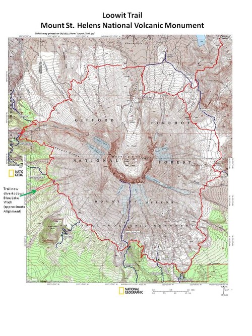
In this time of idleness, the purgatory between exploration and earning money, I often feel like a spring being compressed. Down, down, down and then boom! Flung out of the house to do something, anything really and not against the will, but by it. At the summit of Mount St Helens three days prior, a climber had told Virginia and I of a loop trail that circles the volcano, completed by most backpackers over the course of 2-3 days. By Sunday afternoon, bored while Virginia was at work, I sprang, and was soon quasi-packed and headed north out of Portland, once again aiming Occupanther towards the massif to the north. Occupanther is our 2006 Chevy Express cargo van mobile adventure headquarters, which we purchased from De Yao Sun (Grandmaster of Mantis Kung Fu) in Atlanta two days after finishing the AT. I pull into the empty Marble Mountain Sno-Park near the base of the mountain, read the first ten pages of the 1910 classic “How to Live on 24 Hours a Day” and go to sleep.
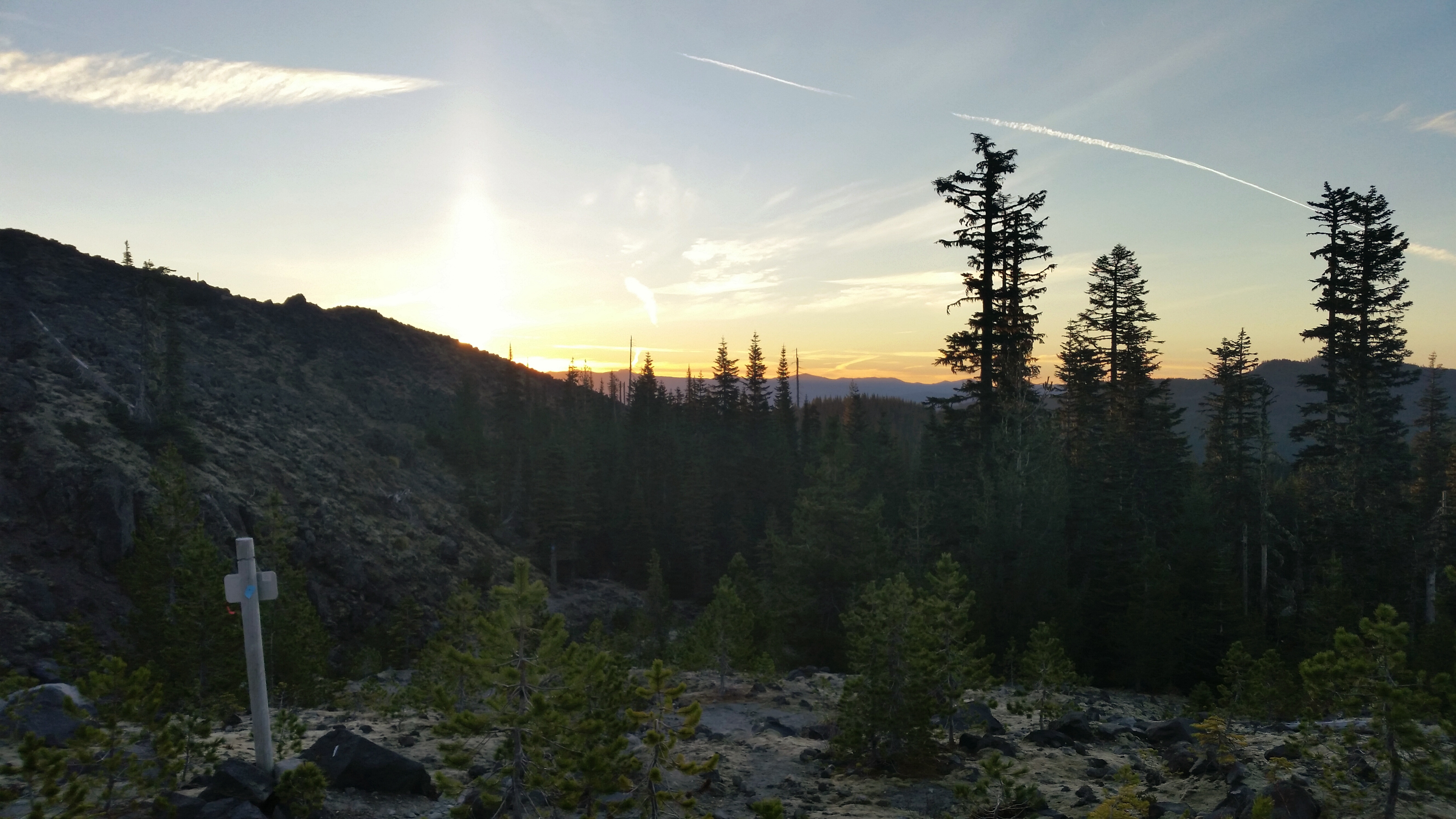
A car door slams and I hear the sound of backpacks being slumped from the trunk of a car onto the concrete next to the van. It’s still dark except for the faint dawn light coming through the opaque roof vent above my head. The clinky-clank of crampons and ice axes, the smell of fresh shower and bath soaps wafting through the vent and then I’m up, groggy with no coffee to start the day. In five minutes I’m on the trail, quickly covering the two miles to the Worm Flows before intersecting with the Loowit Trail, the 30-mile circuit I’ve planned to complete in one counterclockwise push. I begin the lollypop loop at 7:05 a.m. with no map and the sole intention of keeping Mount St Helens portside.
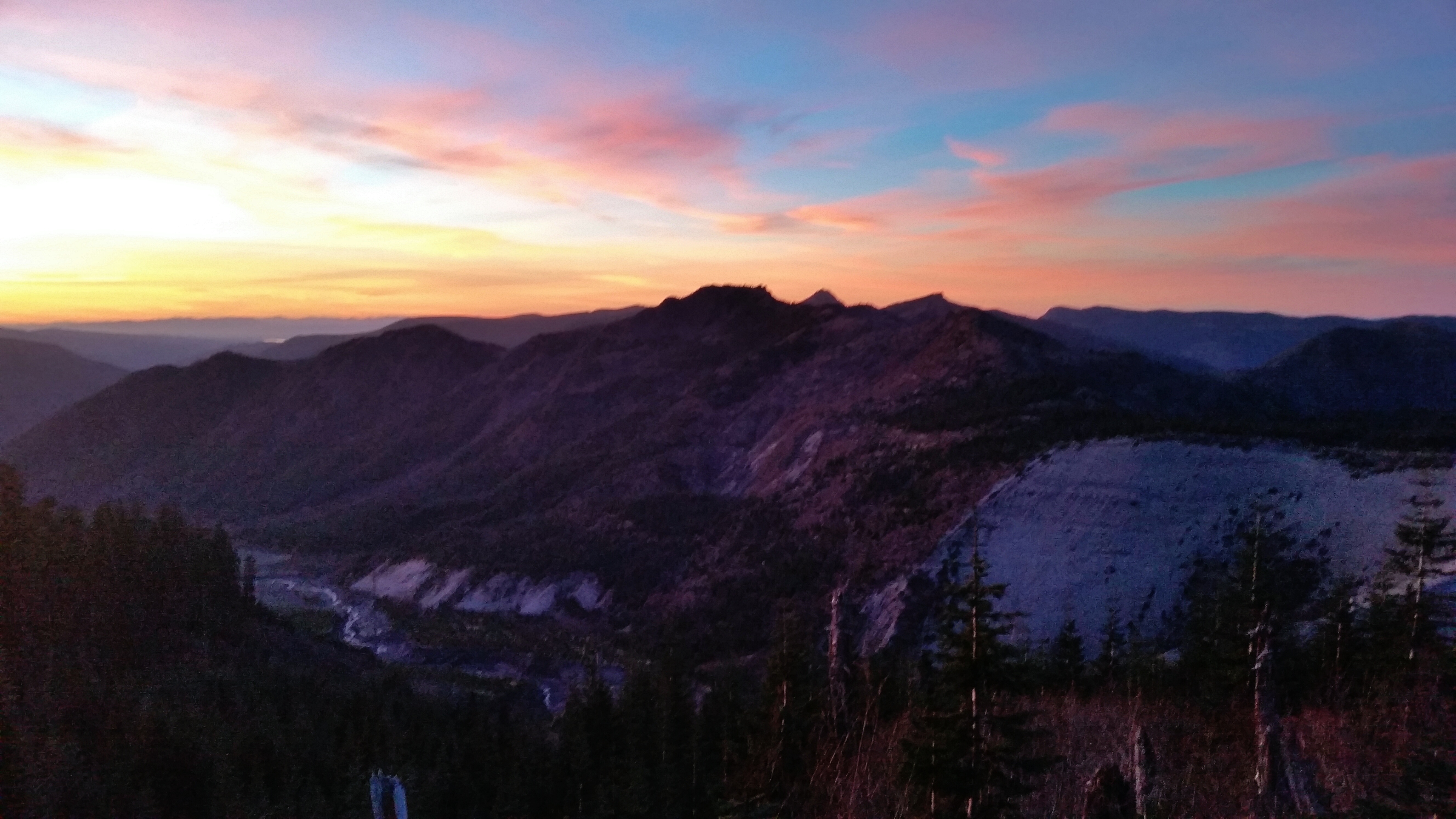
 A woodsy trail winds along the southern flanks, past June Lake, opening into scrambles of scree fields and deep ravines that channel water from the slopes, cutting steep-walled canyons through the 34-year-old mudflow. At the height of spring I can imagine the torrent that flows here, but at the moment there is only the smallest trickle. I scoop a handful of the icy water and slurp it down. The silty taste of snowmelt is refreshing and I fill my liter bottle and ascend the ravines steep walls. At the top I dump out a shoe full of volcanic ash and have a breakfast of a dozen chocolate covered pretzels and a few handfuls of spicy fiesta peanut mix. A gulp of volcano water washes this down as I admire Mt Adams rising majestically to the East; it’s southern face aglow.

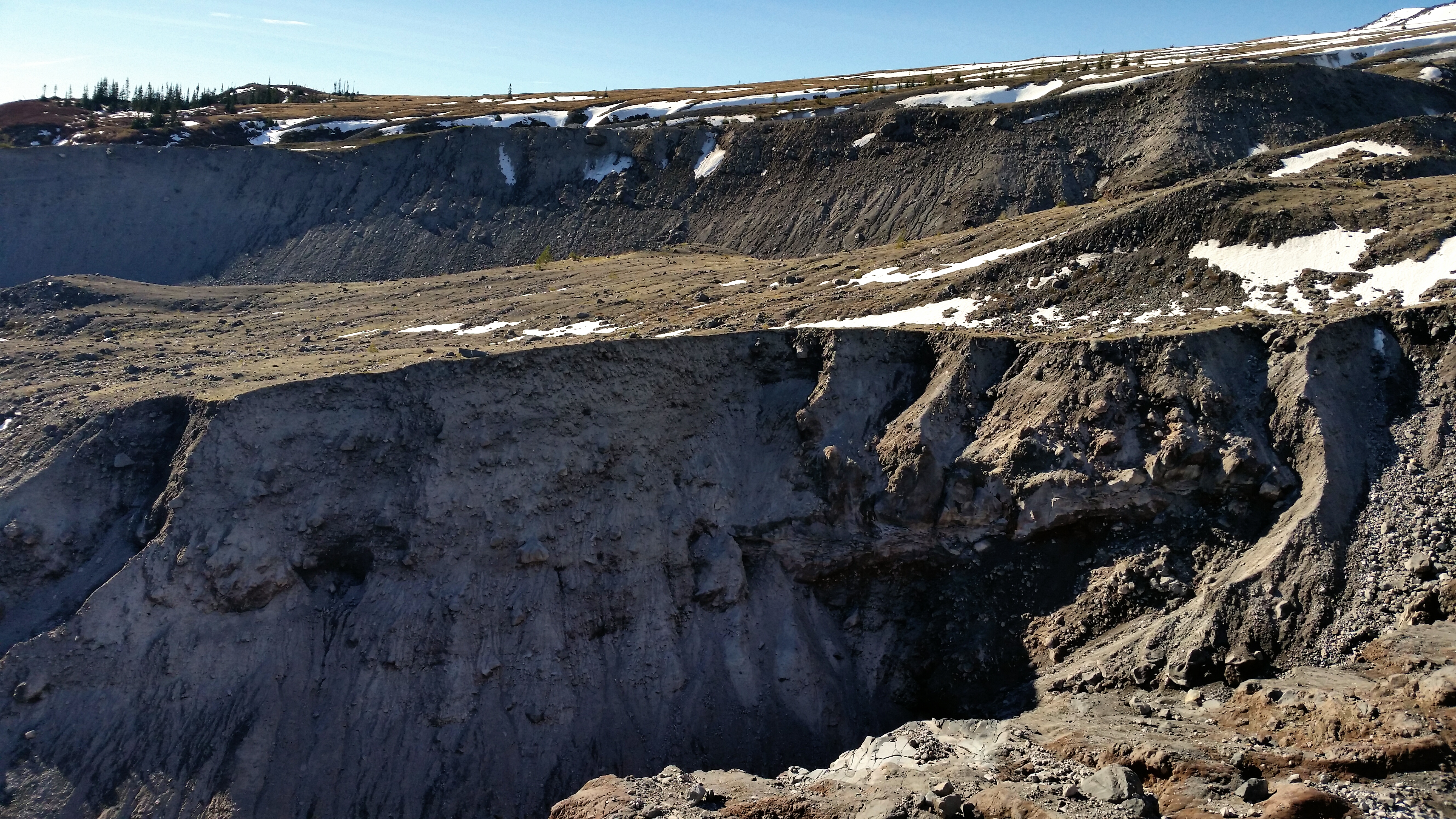
Erosion of the mudflows, a consistent feature along the Loowit.
The route winds up and over into a clearing just above timberline. The mudflows give way to blown down forest and the meadow is quick underfoot The sun-bleached skeletons of trees punctuate the landscape, while new-growth conifers stand only a few feet high at their base, eager to take their place in the once-sterile debris fields. I run my hand along the fluorescent green tops of the new growth, slightly bending and releasing them as they spring back with vigor. Seemingly every quarter mile the trail is cut on the perpendicular by a steep gully, requiring careful footing on the descent and a keen eye for markings of an appropriate ascent. Along a grassy hillside I spook a herd of several dozen elk below in a wash and they break into a frenzy, half of them running east, the others west, each one blindly following in the fearful footsteps of their peers for a minute or two before stopping and looking about, as if they’d all forgotten what they were running from. By 11 a.m. I’d covered about seven miles, a relative slugs pace, and simple math stated that at this velocity I’d still be at it this time tomorrow.
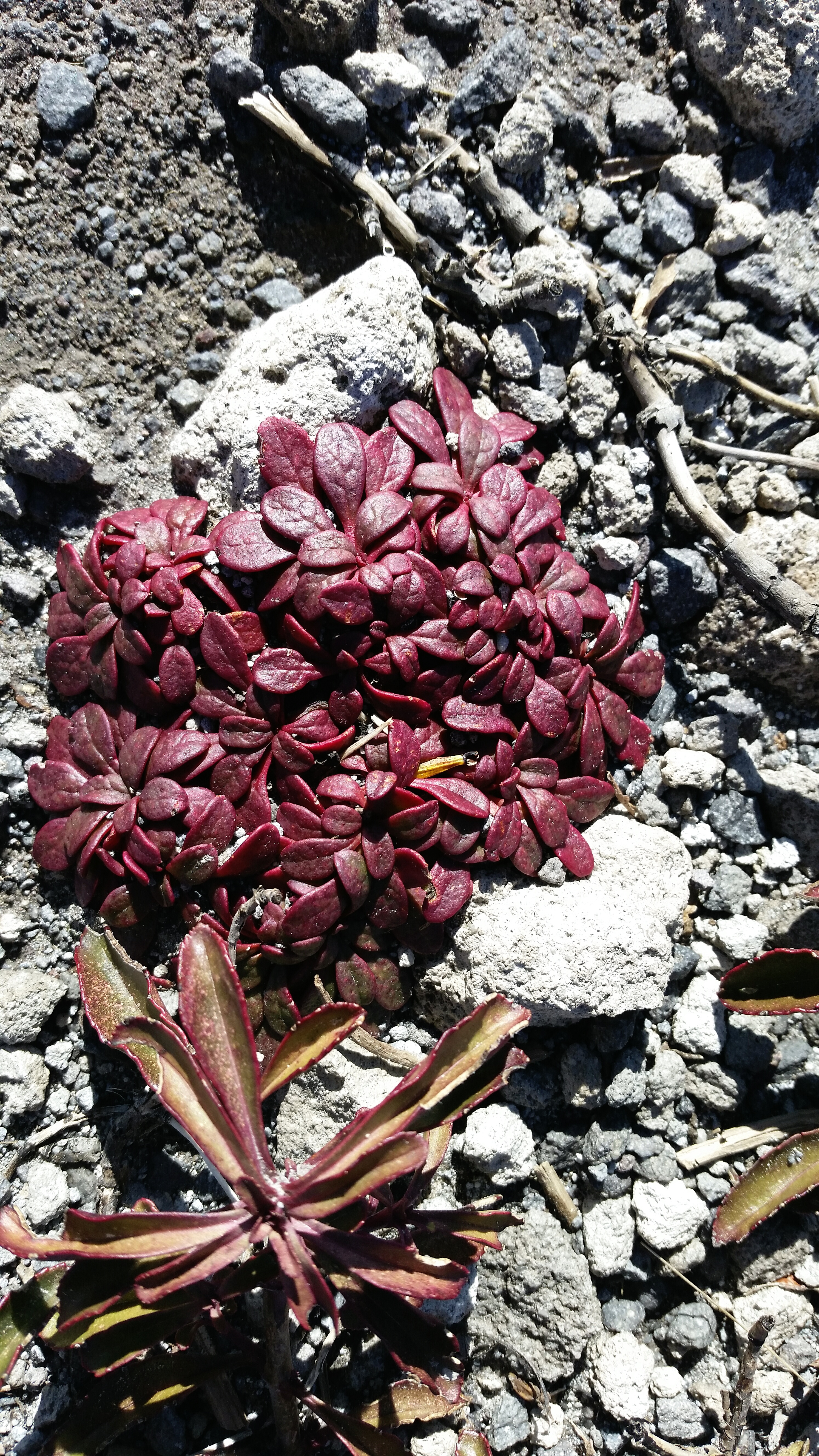
I pass a trail junction leading to Ape Canyon, the site of an alleged Bigfoot encounter in 1924. According to the report, a miner named Fred Beck shot and perhaps killed one of several “ape men” who were throwing stones and attacking his cabin. Ol’ Fred identified them as mystical beings from another dimension, considering the experience to be just one of many in a life filled with visions and psychic premonitions. I continue north into the plains; a barren volcanic desert, void of life during the winter, save for one tiny burgundy plant which dots the colorless landscape and seems to thrive in its wasteland. Pumice the size of watermelons dot the ground, looking as if they had hellishly rained down from above as St Helens blew steam and ash into the stratosphere. During the lush spring this area will fill with the color of lupine, paintbrush, and penstemon, but at the moment it’s a veritable moonscape. With much effort, I spot no sign of sasquatch, only half a dozen mountain goats at the top of a rise that eye me suspiciously as I trot by.
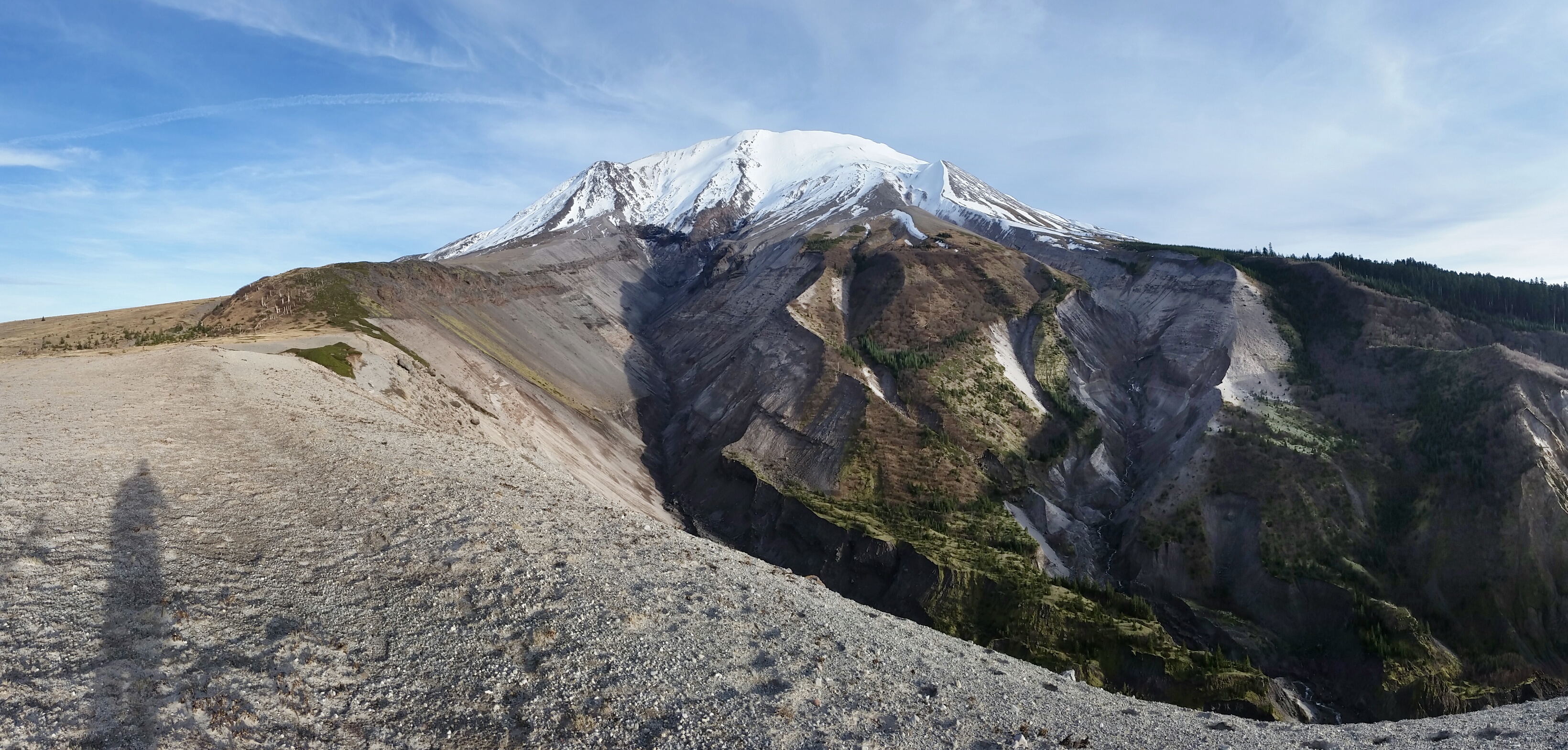
 Around noon I pass a sign stating, “ENTERING RESTRICTED AREA, STAY ON TRAIL, NO CAMPING”. The next 10 miles swing westward across the breach zone; somewhere you wouldn’t have wanted to be in mid-May, 1980. Thanks in part to the restrictions now in place and natures inherent tenacity, the vegetation and wildlife are recovering faster than anticipated. The volcano becomes more defined at this point, it’s entire northern section gone and the 1980 lava dome visible. I try to imagine the 1200-degree pyroclastic flow raging from the mouth of the volcano, creating the pumice rock plain that I now stand on. Looking up into the crater I squint into the sun in an attempt to spot climbers standing along its rim. If anyone is there, I can’t see them and continue down the ribbon of trail across the fields. Once again I manage to spook a large herd of elk after topping out over a rise, maybe a hundred yards out, and this time they fall in single file, trotting nervously across the plain, coming to a escarpment before turning back and climbing a steep hillside up to a high ridge. Behind them, the snow covered, northeast corner of the crater frames the group of at least fifty as they stop and watch my direction, making certain that the strange creature for which they are instinctually afraid (and rightly so) wasn’t giving chase. I shot the video below as they snaked up the hillside.
A side trail leads ¼ mile to the 200-ft Loowit Falls, where I find a windbreak behind a pile of stones and prepare a lunch of white cheddar instant mashed potatoes, which has been soaking in my pack for several hours. Gritty and flavorless, I scrape the container clean with my titanium spork (with half of the handle removed, naturally) and chase it down with another dozen chocolate pretzels, a package of Cookies & Cream Pop Tarts, and a gulp of melted snow. I poke and prod at the slowly disintegrating shoes on my feet. The lava red Brooks Cascadia’s have over 1,500 miles on the clock, and the uppers are just beginning to rip along the sides from the stress of my widened feet. I make a mental note to write to Brooks thanking them for the longevity of the shoe which I’d purchased on sale in Lower Manhattan just six months ago. The falls are grey and cold, and the wind swirls the mist up and out of the canyon in little cyclones. The abundance of fresh water here is surprising, and no doubt instrumental in the gradual reintroduction of life to the pumice plain. The rise in humidity next to the falls, coupled with increasing winds from the south forces me back down and onward across the restricted area.
With trekking poles I vault over a braided stream just down from the falls, only slipping in once, its icy waters forming slurry with the ash in my toe box. As the trail winds west out of the pumice fields, life grows abundant and the hills are tinged green with grass. The elk that had spooked earlier in the plains now pop into view again, still higher on a plateau although close enough to count individuals. Evidence of the explosion is apparent in the hills to the northwest as hundreds of trees lay in perfect parallel, looking like a bad comb over. The trail turns onto the rim of a canyon and down into a large switchback through ankle deep ash. Sinking down with every step, I descend 800 feet to the South Fork of the Toutle River as the sun falls lower and lower to the horizon. A rope tied to several large rocks assists the final drop, and I chunk my poles and use the rope to slide down to waters edge. Looking upstream to the source, the river has eroded a steep canyon through the muddy debris. During the pyroclastic flows following the eruption, melting ice and snow created enormous mudflows, and the resulting torrent altered six major rivers downstream of the Toutle, destroying numerous bridges and killing dozens of people in its path. I pick a route across the swift but shallow current and walk downstream where I find a scramble to the top of the freshly eroded canyon. The trail turns back uphill to the east, following the edge of the canyon wall before climbing through old-growth forest up to the base of the volcano. At tree line the western flank of the prominence stands silent in the cool breeze and alpenglow, and I stop to change clothes. Three elk tromp through the brush downwind , the horizon glows a fiery red.
The canyon formed by the South Fork of the Toutle River.
It’s approaching 6:30 p.m. with 12 miles still left in the circuit, and I pull my headlamp and mini-flashlight from a hip belt pocket. At a 2 mph pace in the dark, I could finish the loop by midnight, assuming the trail is fairly visible. Orienteering in this country could take some time. With my standard 3 LED headlamp strapped around my skull and the Fenix LD01 in hand, I have a fairly good light system; a broad flood for following trail, and a focused beam for finding landmarks and scouting routes across the canyons of rock and mud that scour the landscape. The route stays high and tight as it heads south, and for the first time in the day I feel like I am on terrestrial Earth. In the growing darkness, the lights of Portland and Vancouver glimmer to the south. I think about the two Lagunitas Ales that are waiting for me in the van, and glug down a bottle of water unfiltered from the Toutle.
Looking back across the Toutle River. The erosion seen to the right marks the route down to the water.
As the time passes the trail becomes rockier, the night darker and cold, and soon I’m searching for signs of passage through talus slopes and rivers of rock. Any sign of loose dirt has diminished and it’s a full on scramble for as far as my 1 ounce, 70-lumen light can shine. I pass a sign saying “Loowit Trail #216, June Lake – 7 —>”, and I know that it’s five miles to the Loowit junction with Worm Flows, and two down to the parking lot. Through the rocks my pace had slowed to something like 1 mph or less. My tiny spotlight, necessary for navigating across the endless gorges, goes dim and I fumble in the dark for a spare AAA battery. The route is loosely marked with wooden poles which stand 6 ft and are held aloft by piles of stones at the base, but many are broken or have fallen and aren’t visible until standing directly over them. For miles I curse and shout to myself as I slowly scramble through the rocky darkness. I find a marker pole, scan the horizon with my spotlight, sometimes catching another marker, sometimes not. I follow a line that seems to coalesce with the route, only to dead end at the base of a steep cliff or peter out at the top of an impassable gorge. Backtrack to the previous marker and search for another way. Shine, search, spot, scramble. This went on for some time before quite abruptly a dirt path appeared on the edge of the woods. My watch read 9 p.m., and I had been on the Loowit for 14 hours.
I find refuge from the incessant wind in a rocky alcove and have a dinner of sunflower butter sandwiches and snowmelt. I feel good and strong. Back on trail my pace quickens to a brisk shuffle as the path winds through brushy forest clearings, across sloping icy snowdrifts and along rocky spines in the dark. I can get an hour and a half from one AAA on the high setting of my tiny spotlight, and again I’m forced to replace the battery after a sudden blackout midway up a canyon wall. I carry the mini-torch at waist level, shining across the terrain so as to create shadows and show depth for finding my way through the night. I descend a set of switchbacks and get a musky whiff of elk just off trail. Car lights wind through the darkness below along Route 503. I’m up and over a rocky rise and then a sign, ‘Worm Flows’ it says. I’ve connected the loop. I turn south and gleefully carry on at 4 mph down the heavily used approach path, hoping that if someone had broken into the van while I was gone that they’d at least left the cooler and the two bottles of suds I’d left as a reward. Occupanther sits alone in the parking lot with all windows and doors in place. I dump my gear into the back, trade the silt-filled trail runners for flip flops, and pop the cap off of a bottle of Lagunitas Lil Sumpin’ Ale, settling back into a folding camp chair almost exactly 16 hours from start time. I’d rambled 35 miles around a volcano that day and not seen another human, and I squint my eyes as the hoppy carbonation tickles my nose.
-David

Very ambitious and cool. Glad you made it out of the dark.
Amazing.. So Amazing!
Lovely blog yoou have
Why thank you! 🙂